|
Vat Phou Asa |
|
|
|
|
|
Address: |
|
|
|
|
|
Known as: |
|
|
|
|
|
Description: |
|
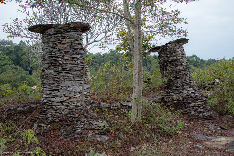
Atop Phou Asa Mountain, above Kiet Ngong Village, stands an
ancient and magnificent stone structure called Wat Phou Asa. It
is believed to be a temple and is surrounded by distinctive,
unique columns made of plate-like rocks which stand proudly as
if guarding the temple. The summit of Phu Asa opens out to
provide a stunning view over large areas of southern Lao. The
forests of Xe Pian and Dong Houa Sao NPAs appear to stretch out
endlessly from the Kiet Ngong wetland. To the north is the
Bolaven Plateau, and on a clear day waterfalls can be seen
cascading from it. Ahead to the east is the Xe Khong floodplain
in Attapeu, and lining the horizon is the Annamite Mountains on
the Vietnamese border. At the top of the outcrop is a ring of
stone pillars. Legends abound about these remains, but it is
unknown if the structure was built for religious or military
reasons.
Phou Asa is reached by a short walk with a local
guide or elephant ride along a forest trail from the village.
Elephant-back trips can also be arranged to other places such as
nearby forests and wetlands. Village guides are available to
take visitors on half or full-day walks to Phou Asa and its
surrounding, interpreting its many medicinal plants and
non-timber forest products. The 7 km long eco-trail begins at
the foot of Phou Asa and offers 3-4 hours of steady walking
through tall semi-evergreen forest.
Also from Kiet Ngong
Village is an extensive wetland, which is good for bird watching
and day hikes. During the dry season (November-April) there is a
trail around the wetland to Don Lai Island, which takes about 2
hours if walked slowly. Many water birds can be seen, so bring
binoculars if you have them. On the way you will pass the Giant
Rock (Hin Houa Yak in Lao), a sacred place with a superb view.
The trail continues to Phapho Vilalge, but you will probably
want to return the way you came. Don Lai Island can also be
reached by canoe. Your boatman will take you slowly around the
edge of the wetland, where a passage through the thick mats of
floating vegetation is kept open by boats and water buffaloes. A
canoe trip offers a closer look at the birds and local fishing
techniques than a walk around the wetland. |
|
|
Province |
|
Champasak |
Direction: |
|
|
|
|
District |
|
|
|
|
|
City |
|
Thang
Beng, |
Comments: |
|
Official Web: |
|
|
|
|
Genre |
|
Ruins |
|
|
Related links: |
|
|
|
|
Best exposure |
|
AM/PM |
|
|
|
|
|
|
|
Rating |
|
  |
|
|
|
|
|
|
|
Opening time |
|
na |
|
|
|
|
|
|
|
Entry fee |
|
Free |
|
|
GPS : |
|
14.76548, 106.02843 |
|
| |
|
|
|
|
|
|
|
|
|
|
|